Praia da Arrifana is a crescent-shaped, cliff-backed beach about 10km southwest of Aljezur on the Algarve's Costa Vicentina. The most popular surf beach on the west coast, it sits in a sheltered bay with a small fishing harbour, consistent Atlantic swells, and the iconic Pedra da Agulha sea stack rising from the water at its southern end.
Why This Beach
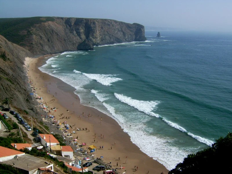
Praia da Arrifana is the Algarve’s west coast at its most dramatic and most accessible. A wide crescent of golden sand, roughly 500 metres long, cupped between dark schist cliffs that rise sharply on both sides. At the southern end, the Pedra da Agulha, a thin black sea stack, juts out of the water like something left behind by a retreating glacier. At the northern end, a small fishing harbour still operates, and above it, the ruins of the Arrifana Fortress offer one of the best coastal viewpoints on the entire Vicentina coast.
The surf is the main draw. Arrifana has hosted regional competitions, and the combination of a beach break in the centre and a point break off the northern headland means there are waves for every level. But this is also the beach that people drive an hour from the southern Algarve to visit just for the setting. The cliffs, the Pedra da Agulha, the tiny whitewashed village perched above: it looks nothing like the resort beaches around Albufeira. That contrast is the point. The name Arrifana derives from the Arabic word “arihana,” meaning myrtle, one of many traces of the Moorish centuries that shaped this coastline.
Worth knowing: the bay’s shape cuts the worst of the Atlantic wind and swell, which makes Arrifana noticeably calmer than neighbouring beaches like Vale Figueiras or Bordeira. Still rough by southern Algarve standards. Not a flat-water swim.
How to Get There
From Aljezur, follow the signs towards Praia da Arrifana (about 10km, roughly 15 minutes by car). The road climbs to the clifftop village, where you park in the free car park above the beach. In summer, this fills before mid-morning. If it’s full, there’s overflow parking along the road, but walking distances increase quickly.
The descent to the beach is steep. A paved road (closed to non-resident vehicles) zigzags down the cliff face, and a wooden ramp at the bottom provides the final stretch onto the sand. The walk down takes five to ten minutes. The walk back up takes longer and feels longer still in the afternoon heat. A shuttle service has operated between the car park and beach during summer. Check locally for current availability.
From Lagos, the drive takes about 45 minutes via the N120 through Bensafrim. From Faro, allow around 90 minutes via the A22 motorway and then the N120 north.
Public transport is not practical. Buses connect Lagos and Faro to Aljezur, but from Aljezur to the beach there is no regular service. A car is essential for the west coast.
What to Bring and What to Know
A wetsuit, or at least be ready to rent one at the beach. The Atlantic here is significantly colder than the southern Algarve coast, even in August. Water temperatures on this stretch of the west coast typically sit around 16-18°C in midsummer. Surf schools and rental outfits operate from the beach area and the village above, offering boards and wetsuits by the hour or the day.
Water shoes are useful if you plan to explore the rock pools around the base of the cliffs, especially at the southern end near the Pedra da Agulha. The rocks are dark schist, rough-edged and slippery when wet.
Sun protection is obvious but shade is not abundant. The cliffs provide some natural shadow in the morning (the beach faces west), but by early afternoon the entire beach is exposed. There is a restaurant at beach level and several more in the village above, so you do not need to bring a full picnic, though carrying water down is sensible.
Two things most visitors miss are above the beach, not on it. The Arrifana Fortress ruins sit on the clifftop south of the village, and the panoramic view from there is worth the short walk even if you have no interest in 17th-century military architecture. Further north along the headland, at Ponta da Atalaia, the ruins of the Ribat de Arrifana are far more significant: a 12th-century Moorish fortified monastery, the only identified ribat in Portugal, classified as a National Monument since 2013. The archaeological remains include the foundations of eight mosques, a minaret base, and a necropolis. It is one of the most important Islamic archaeological sites on the Iberian Peninsula, and most beachgoers walk right past the trailhead without knowing it is there.
The village of Arrifana has several restaurants. Percebes (goose barnacles) are the local specialty, harvested from the rocks along this coast. Not cheap, but ordering them here is about as close to the source as you can get.
Nearby Beaches
Praia da Bordeira is about 20 minutes south by car, near Carrapateira. A completely different experience: enormous, wide open, backed by dunes, with a river crossing the sand to the sea. Warmer, shallower pools where the river meets the beach make it better for small children. Bordeira trades Arrifana’s drama for sheer scale, and it is almost always quieter because the remoteness filters out casual visitors.
Praia do Monte Clérigo is roughly 15 minutes north, closer to Aljezur. A more sheltered bay with a small village behind it, calmer water, and a more family-friendly setup. If Arrifana’s waves look too serious for a relaxed swim, Monte Clérigo is the backup.
Praia do Amado, further south near Carrapateira, is another major surf beach. Bigger, more exposed, with a different wave character. Surfers often check both Arrifana and Amado conditions and drive to whichever is working better on the day.
The point break works off the northern headland near the fishing harbour. Beginners should stick to the centre of the beach where the beach break is gentler and surf schools operate.